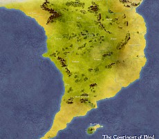
Maps
 Mapping is of vital importance to any society if it is to understand it place in it's world, but isolated and insulated communities are not noted for map making; when local knowledge is enough, anything more than a rough guide is nothing more than curiosity.
But when events have wider implications than the local, without good maps control of any situation is impossible. In addition, if you are wishing to have exclusive control over your populace, then the widespread adoption of good maps may want to be discourages. It is not surprise therefore that the best existing maps have tended to be of sea routes and land masses have, from empire to empire, been poorly maintained.
Most of the maps here are inspired by the work of Mistry Jinx, to whom map making was not just a necessity, but almost a philosophy. Do note, however, that areas that appear empty are only so because of a lack of information, not that there is nothing there!
Please be assured that as more information does come to light, the cartographers will update the maps.

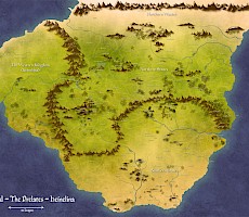

Tepid Lakes and The Beacon of Hope
Centering on Tepid Lakes, this also shows the area from Sarn in the south up to Heldon Heights (The Beacon of Hope)


Series one and two from Amazon, Smashwords, Kobo, Barnes & Noble, Apple and more!
Start with Dirt for FREE
Distances
The normal distance on Dirt is the League and this is used on both land and water.
Rough measurements of short distances are in paces.
Scale & Accuracy
The distances between features on the map is reasonably accurate, though some maps are scaled differently and it is important to note any distance guide on the particular map.
Where this rule may be broken is between places that are very close together. For instance, the villages of Sarn-Tailin, Sarn-Appton and Sarn-Linton are closer together in reality than shown on larger maps.
Features are often shown as far bigger than they may be in reality; their location and importance being more critical than their actual size. Mountains and some woodland are examples of this.